Before Telescopes: How People Mapped the Sky
Before telescopes, people mapped the sky by watching stars repeat, recording their positions and turning scattered observations into shared patterns.
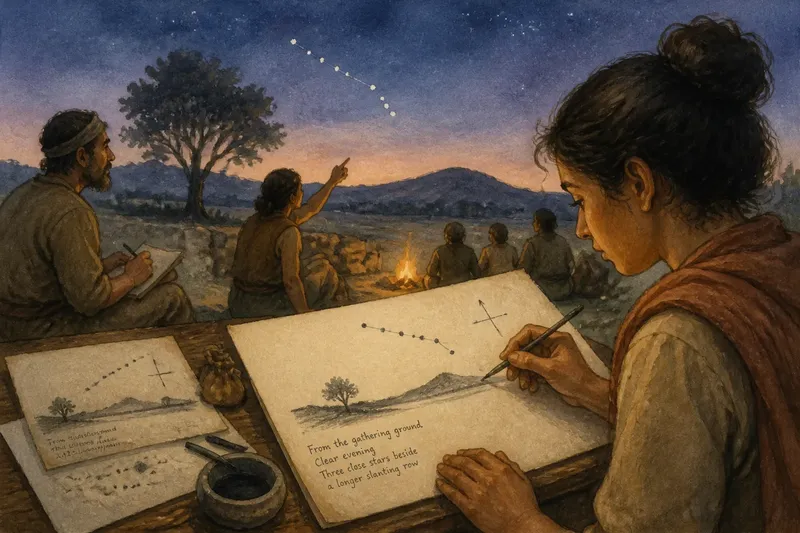
Before telescopes, a clear evening could begin with a charcoal mark beside a star and end with a question: had that bright point moved, or had the observer’s memory slipped? Before telescopes, people mapped the sky through repeated naked-eye observations, drawn records and comparisons made across nights and seasons. Imagine an invented village whose observers decide to build a dependable record of the stars above a familiar hill. Their project shows how patient looking turned the sky into something that could be described, remembered and passed on.
A familiar horizon gives the record its first frame
The villagers begin with what they can return to: a low ridge, a distinctive tree and the open ground where they gather after dusk. These are not decorative details. A fixed horizon helps an observer distinguish a celestial pattern’s position from the observer’s own shifting viewpoint.
They choose a level patch of ground and mark a few directions using local landmarks. One observer sketches the ridge and notes where a conspicuous star rises in relation to it. Another watches from the same place on a later clear night. Their first map is not a complete picture of the heavens; it is a record tied to a particular view.
That limitation is useful. A drawing that says only “the bright star is near the edge” can mean little to someone standing elsewhere. A drawing that also identifies the hill, the tree and the direction of sight offers a frame another observer can recognise.
Start with a stable place and a recognisable horizon before trying to make a sky map cover everything.
Repeated nights separate pattern from impression
On the first evening, the group notices a cluster of stars forming a bent line. It looks distinctive, but descriptions made from memory disagree: one person calls it a hook, another a narrow triangle. Rather than settle the argument by choosing the most vivid description, they return on later nights and compare what they see.
They draw the stars as dots, keeping their relative arrangement rather than attempting to reproduce the exact appearance of the sky. A line or shape can help a reader recognise a group, but the dots carry the more useful information: which stars appear close together, which are brighter, and where one sits in relation to another.
Repetition reveals which features remain consistent. A pattern of several stars keeps its shape from one observation to the next, even as its position above the local horizon changes. A single night’s sketch might capture a fleeting impression; drawings made on separate nights give observers a way to judge whether they are describing the sky or merely remembering it imperfectly.
The villagers therefore leave room beside each drawing for a note about the observing evening. They record the visible horizon, the stars they could identify and anything that made the view unclear, such as cloud or haze. The note does not make the sketch exact, but it tells a later reader what the drawing can reasonably claim.
Drawings turn watching into a shared reference
A sketch becomes more useful when another person can read it without hearing the artist explain every mark. The villagers settle on simple conventions: dots for stars, a heavier mark for a notably bright one, and light connecting strokes only where they help distinguish the pattern. They add a direction marker and label familiar landmarks.
This is an invented reconstruction, not a claim about one historical community. Its practical point is that a record depends on choices about what to show. A drawing overloaded with imagined figures may be memorable but can obscure the star positions; a bare scattering of dots may be hard to recognise. A restrained map can preserve both a pattern and enough context to find it again.
Say the village’s youngest observer makes a new sketch after the group has watched the same section of sky on several clear evenings. She places the dots by comparing them with a straight edge drawn between two bright stars, then adds the ridge and a note that the view was made from the gathering ground. The expected observable result is not a perfect portrait, but a drawing another watcher can compare against the sky and the group’s earlier record.
Written labels matter too. A short description such as “three close stars beside a longer slanting row” gives a reader another route into the map if a mark has faded or a drawing is unclear. Maps and verbal descriptions reinforce one another rather than competing for authority.
Seasonal return gives the map a wider purpose
As the villagers keep observing, they notice that the familiar pattern does not appear in the same part of the evening sky throughout the year. It is visible at one season and harder to see at another. A map made only to identify a pattern on one night cannot explain that change in visibility.
They begin a second kind of record: not a new drawing for every evening, but a note about when the pattern is first easy to recognise after dusk and which neighbouring patterns appear with it. This turns a collection of sketches into a rough account of the sky’s recurring order. It can help observers anticipate what they might see without suggesting that every night will offer the same conditions.
The distinction is important. A sky map can show how stars relate to one another, while a seasonal note records when that arrangement becomes useful to an observer. One gives a spatial guide; the other adds a calendar-like rhythm. Together, they let people organise observations across both place and time.
For the fictional village, this has an everyday consequence. Someone planning an evening gathering can consult the record to choose a season when the familiar stars are likely to be visible after dark. The map does not promise clear skies; it helps the group know what to look for when the sky allows.
How did people record stars without telescopes?
What could the naked eye reveal?
Unaided eyes could show bright stars, their relative arrangement and how patterns appeared against the horizon. Careful repeated observation could also distinguish a steady-looking background pattern from objects whose positions appeared to change, though the detail remained limited by what the eye could resolve.
Why draw the horizon on a star map?
The horizon anchors a view to a place and direction, helping a reader understand where a pattern appeared to rise or sit above familiar landmarks. Without that frame, a sketch may preserve the stars’ arrangement while giving little help in recreating the original observation.
Did early sky maps show the whole sky at once?
Many useful records could focus on a portion of the sky or on a particular observing purpose. A group could make several local sketches and connect them through descriptions, rather than needing one drawing that represented every star and every viewing direction.
What changed when telescopes arrived?
Telescopes revealed objects and details too faint or small for naked-eye maps, expanding what observers could record. They did not make the older habits of locating, comparing and documenting patterns pointless: those habits still helped people describe where an observation belonged.
Maps carried decisions as well as observations
Every map leaves something out. The villagers’ drawings omit faint stars they cannot reliably distinguish; they also simplify distances and choose which groupings deserve labels. Those choices do not automatically make a map misleading. They show that a map is built for a purpose, and that readers should know what it includes.
A record designed to help a newcomer recognise a pattern may connect stars with faint lines. Another intended to compare positions may avoid those lines and use written descriptions instead. Neither is a view from nowhere. Each reflects what its makers wanted the next observer to notice.
This is why a run of maps can reveal more than a single polished drawing. Differences between records may point to changing visibility, different observing places or a shift in how the group categorised the stars. Keeping earlier sketches allows later observers to compare decisions, not simply inherit the latest version as if it had always been obvious.
Preserve rough drafts alongside the clean copy; the revisions can explain how a pattern was recognised.
What the village’s finished record can and cannot do
By the end of the invented project, the group has a set of drawings, a description of its observing place and notes about when familiar patterns return to view. A new watcher can use those records to recognise selected star groups, compare them with earlier observations and understand why a particular sketch looks the way it does.
The record cannot show every faint object or settle every disagreement about how stars ought to be grouped. Nor can it substitute for seeing the sky. Its strength lies elsewhere: it turns individual acts of looking into observations that can be checked, discussed and continued by other people.
That is the enduring value of mapping before telescopes. A recognisable pattern did not begin as a fixed picture waiting to be discovered; it took shape through repeated attention, practical marks and shared descriptions. When you consult a modern sky map, notice the small decisions behind its clarity: where the view is anchored, which stars are linked and what the map asks you to recognise. Those choices are the quiet craft that made the sky readable long before glass brought distant details closer.